 Sunshine and buffeting winds accompanied us on our drive south
yesterday, heading first westward on the M1, before turning south and on
through Portadown and Tandragee, and finally west again on the minor B3 into
the Cusher valley to our little campsite here on a farm. From our caravan we
have views down toward the river, across recently re-sown fields which accounts
for the bird-scarer cannon blasting away yesterday.
Sunshine and buffeting winds accompanied us on our drive south
yesterday, heading first westward on the M1, before turning south and on
through Portadown and Tandragee, and finally west again on the minor B3 into
the Cusher valley to our little campsite here on a farm. From our caravan we
have views down toward the river, across recently re-sown fields which accounts
for the bird-scarer cannon blasting away yesterday.
Speaking of blasts, we never did identify the gunshot or blasts
heard when we were camped at Larne, even by asking the employee in the service
station opposite the camp or another in the Asda supermarket who said he lived
in the city. The former did mention that she had been asked the same question
by other campers; I had wondered if the occupants had become so immune to such
sounds over the years, they now no longer heeded them.
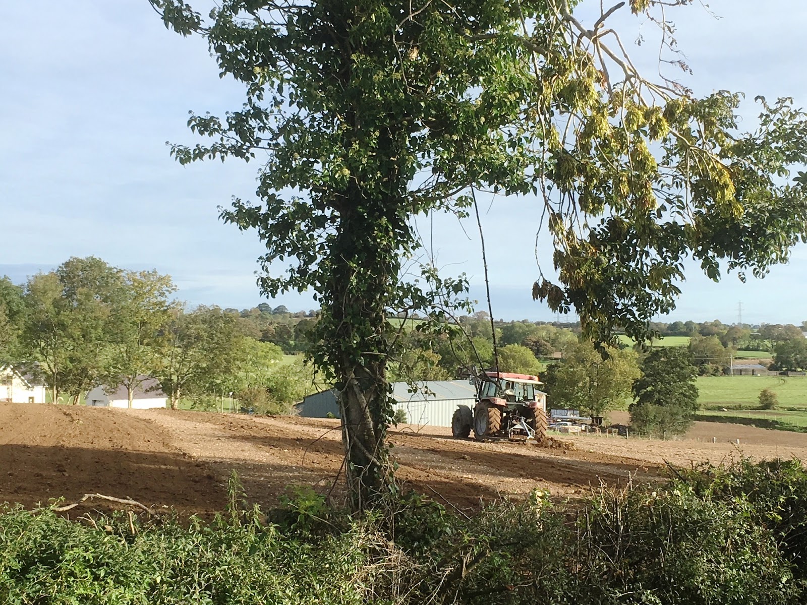
This morning the farmer arrived in the next field while we were
still having breakfast, driving his tractor back and forth, harrowing the
ploughed field, and then this afternoon, he repeated the process.

 We headed away into County Down to explore the Mountains of
Mourne, which most folk who enjoy listening to Irish ballads will be familiar
with. Our route took us south to Newry through a tangle of motorways and
highways, then eastwards on the B8 to Hilltown, before heading south through
the mountains on the B25. The road rose up over a saddle, past a small plantation
of pines that had been decimated by last week’s storm, then down to Rostrevor
on the Carlingford Lough, a very picturesque descent toward a waterway more
like a fjord than your run-of-the-mill bay. The village is built on the steep lower
slopes of Slieve Martin and while we passed quickly through the business end of
the settlement, we did pause at the Lough edge to take in the serene scene and
the Republic’s highlands across the water.
We headed away into County Down to explore the Mountains of
Mourne, which most folk who enjoy listening to Irish ballads will be familiar
with. Our route took us south to Newry through a tangle of motorways and
highways, then eastwards on the B8 to Hilltown, before heading south through
the mountains on the B25. The road rose up over a saddle, past a small plantation
of pines that had been decimated by last week’s storm, then down to Rostrevor
on the Carlingford Lough, a very picturesque descent toward a waterway more
like a fjord than your run-of-the-mill bay. The village is built on the steep lower
slopes of Slieve Martin and while we passed quickly through the business end of
the settlement, we did pause at the Lough edge to take in the serene scene and
the Republic’s highlands across the water.
The Chauffeur had been instrumental in plotting the day’s route
after my general suggestions, and so I was delighted that he was keen to zigzag
all over this range to see as much as possible, a route I would not have dared
suggest. He did ask me to calculate the distance accepting that it might end up
to be an absurd day’s outing, however when I advised it to be a little over one
hundred miles, he was quite satisfied.

 Having come south, we then pressed on eastward along the A2, on
down the Lough, through Kilowen, across the north head to Kilkeel where we
headed north once more, following the B27. Spotting a sign indicating a detour
to the Silent Valley, we headed off along narrow farm lanes, finally arriving
at the entrance to the Silent Valley Reservoir and a sandwich board advertising
the entry fee. It would have cost us £4.50 to drive in and while this would
have been absolutely reasonable had this been the one destination of the day
and we were planning to walk about the area around the 674 metre high Slieve
Binnian. Alas we were not; we had been drawn particularly by what appeared to
be a straight wall built all the way to the top.
Having come south, we then pressed on eastward along the A2, on
down the Lough, through Kilowen, across the north head to Kilkeel where we
headed north once more, following the B27. Spotting a sign indicating a detour
to the Silent Valley, we headed off along narrow farm lanes, finally arriving
at the entrance to the Silent Valley Reservoir and a sandwich board advertising
the entry fee. It would have cost us £4.50 to drive in and while this would
have been absolutely reasonable had this been the one destination of the day
and we were planning to walk about the area around the 674 metre high Slieve
Binnian. Alas we were not; we had been drawn particularly by what appeared to
be a straight wall built all the way to the top.
Perhaps if we had gone on into the Silent Valley park area, we
might have learned about this wall, but it was not until we returned this
evening that I did a little research and found this to be even more astounding
that the vision that had met us today.
The Mourne Wall was constructed between 1904 and 1922 by the Belfast
City and District Water Commissioners to enclose a catchment area for the
purposes of providing water for Belfast and most of County Down. The granite wall,
crafted from the stone of these mountains, is about one and a half metres high
and a little under one metre thick, and passes over fifteen mountains.
Looking at just this one section on the side of Slieve Binnian, we
joked about the problems that might be encountered building it; exhaustingly carrying
the stones up the steep hill, then having one or two or more roll down to the
bottom after all that effort. When one considers the extent of the wall, surely
such problems must have arisen, and I doubt they were considered comic.

I remarked today that the bare shoreline suggested unusually low
water levels and later found I was right. The rains we have enjoyed during our
travels in the island of Ireland have helped remedy the situation in part. Back
in July hundreds of locals visited the dam to walk along the revealed road,
some of this still visible today.

 We wandered down to the shore and back, the cold wind hastening
our retreat. We had risen to 4 degree temperatures this morning and there seemed
little improvement during the course of the day. Around the other side of the
reservoir, we parked near the dam, which was well fenced off from the general
public. We walked down the road to seek views north across the County Down into County Armagh and back toward Belfast,
before lunching in the car and enjoying the views over the water from the
shelter of the car.
We wandered down to the shore and back, the cold wind hastening
our retreat. We had risen to 4 degree temperatures this morning and there seemed
little improvement during the course of the day. Around the other side of the
reservoir, we parked near the dam, which was well fenced off from the general
public. We walked down the road to seek views north across the County Down into County Armagh and back toward Belfast,
before lunching in the car and enjoying the views over the water from the
shelter of the car.
From here we had planned to carry on up, or rather steeply down, along
the same road, but instead decided to retrace our route a little and cross down
between Slieve Bearnagh and Craigdoo, 720 metres ASL and 402 metres ASL
respectively, and on east along the B180 to Newcastle on the coast.
 Newcastle was a surprise, far bigger than we expected. Parking at
the waterfront, the promenade stretching attractively east and west of our
parking spot, with Slieve Donard, this 852 metres ASL, rising abruptly to the south, we walked up through the main
street, full of closed slot machines premises and fun parlours, and a few
scurrying locals and the same number of well wrapped up tourists. We rather
liked the place, especially without the holiday crowds and razzamatazz that
would surely accompany all that.
Newcastle was a surprise, far bigger than we expected. Parking at
the waterfront, the promenade stretching attractively east and west of our
parking spot, with Slieve Donard, this 852 metres ASL, rising abruptly to the south, we walked up through the main
street, full of closed slot machines premises and fun parlours, and a few
scurrying locals and the same number of well wrapped up tourists. We rather
liked the place, especially without the holiday crowds and razzamatazz that
would surely accompany all that.
The A2, that which runs all the way south past the Giant’s Causeway
and on down past Larne, that which we have travelled sections of over the past
week or so, carried on from here, now named the Mourne Coastal route, hugging
the coast and delighting us in the process.
 At Annalong we checked out the harbour only because it seemed remarkable
that such a place
At Annalong we checked out the harbour only because it seemed remarkable
that such a place could have space or the conditions for such, surprised to find this tucked away below the village, one of the most sheltered mooring spots we had ever seen. The entrance to this little refuge is via a high walled labyrinth, which might well be tricky if the sea was wild.
Further on we arrived once more at Kilkeel, even bigger than we
had deduced earlier. We learned this little town of about seven thousand
inhabitants has one of the largest fishing fleets in Ireland. Pity we didn’t
check Kilkeel’s harbour out. Instead we
noticed the men of the town were all gathering for a funeral at the
Presbyterian Church.
 On we went, now passing through Killowen, once more within the Lough
and now seeing evidence of fishing vessels. On again and we passed Rostrevor,
then onto new ground as the Lough narrowed to such an extent that now at low
tide, the river channel down from Newry seems more a paddling pool for wading
birds than anything else.
On we went, now passing through Killowen, once more within the Lough
and now seeing evidence of fishing vessels. On again and we passed Rostrevor,
then onto new ground as the Lough narrowed to such an extent that now at low
tide, the river channel down from Newry seems more a paddling pool for wading
birds than anything else.
We arrived in Newry, a city of about twenty seven thousand
people, just north of the border with the Republic and the scene of several
violent incidents during the Troubles, even as recently as 2010, long after the
Good Friday Agreement. As we had passed through the northern reaches of the town
earlier in the day, we had passed the police station, a great fortressed
compound such as those seen in several areas around this part of the province.
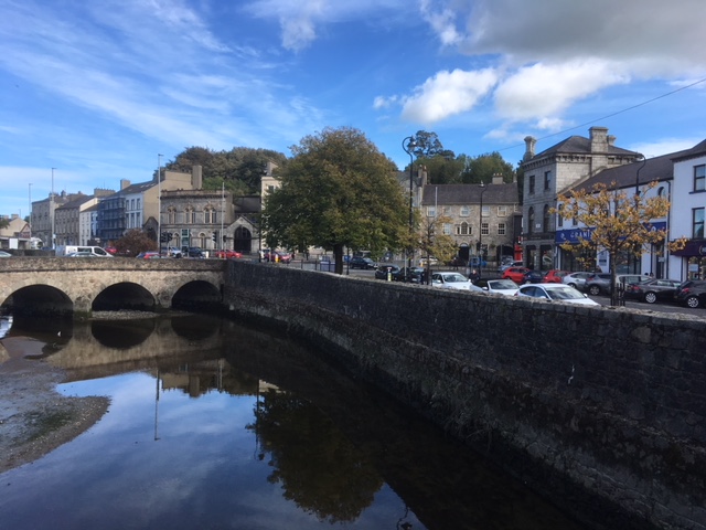 We parked next to the Newry Canal, a body of water contrasting
with the piddle finding its way into the Lough. The canal turned out to be
something of a surprise, this built in 1742 linking Lough Neagh by the first
summit-level canal to be built in Ireland or Great Britain. This explains how naval
vessels have found their way into the “land locked” lough in the past,
something we had learned of when we walked from Antrim to that Lough a week ago.
We parked next to the Newry Canal, a body of water contrasting
with the piddle finding its way into the Lough. The canal turned out to be
something of a surprise, this built in 1742 linking Lough Neagh by the first
summit-level canal to be built in Ireland or Great Britain. This explains how naval
vessels have found their way into the “land locked” lough in the past,
something we had learned of when we walked from Antrim to that Lough a week ago. 
Wandering up the High Street, we found all the retail amenities
people would need of such a place, but little grabbed our attention aside from
a small greengrocer shop where we purchased a bag of carrots.
The Newry Catholic Cathedral in this same street rather dominates
its surroundings and caused us to stop to take a photo. While doing so we were
accosted by a local chap who told us that it had been built on a swamp and the
foundations were of wood. I later tried to check this and found nothing to
authenticate the claim, however I did learn construction was completed in 1829
and that it was the first Catholic Cathedral in Ireland opened after Catholic
Emancipation. I learned too that one can take a tour to learn more about the
stained glass windows, the Italian marble altars and other bits but no mention
of the swamp or the wooden foundations.
From here it was a quick run home where we found the one fellow
camper of last night gone and the site to ourselves and the farmer and his tractor
working until the late hours in the dark.
No comments:
Post a Comment