I think I’m losing my touch as regards tour organisation; today we
found ourselves again frustrated with bad planning, closures and inconvenient
weather conditions. This was our last full day in Northern Ireland, in fact our
last full day in the island of Ireland and should have been more memorable.
After popping into that excellent supermarket in Markethill for a
couple of items, we headed south deliberately staying off the roads already
travelled, soon arriving at Bessbrook just north of Newry.


The National Trust has owned and managed Derrymore House and the
surrounding parkland since 1952, a wonderful area open to all and today that
was one of our destinations.
We had understood this estate was situated off the High Street in
Bessbrook, and we spent some time driving and walking around looking for it,
finally giving up and decided to head on to the next attraction. We headed
south again, now toward Camlough, and lo and behold, we passed the Quaker
meeting house and the entrance to the demesne; how lucky was that!
 Of course we immediately reverted to Plan A and drove up into the
park, full of mature trees turning with the season, a mass of autumnal colour.
We parked up behind Derrymore House, understanding that it was not open to the
public today but still keen to poke around as much as we could.
Of course we immediately reverted to Plan A and drove up into the
park, full of mature trees turning with the season, a mass of autumnal colour.
We parked up behind Derrymore House, understanding that it was not open to the
public today but still keen to poke around as much as we could. After a half hour walk up into the woods and about the meeting house,
which is locked up tight because of years of vandalism , and the graveyard very
plain by British standards, enjoying the birdlife, the conkers and the
wonderful clusters of fungi, and of course the fresh air and opportunity for
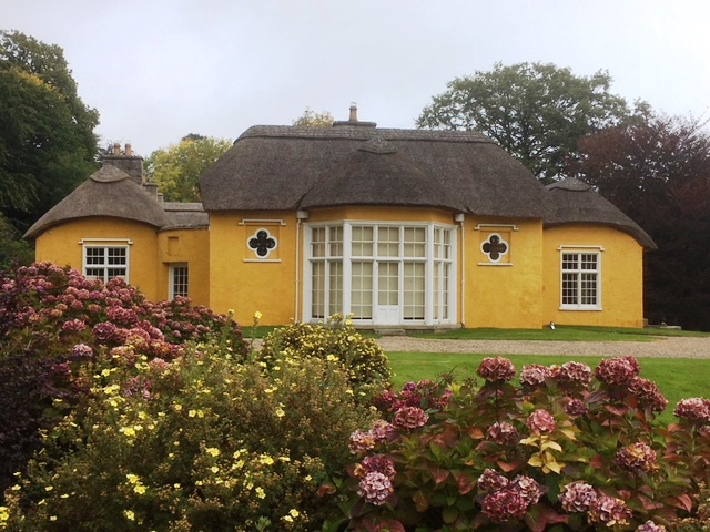
exercise. On our return we wandered around the yellow thatched house, delighting
in its charm and quirky colour.
After a half hour walk up into the woods and about the meeting house,
which is locked up tight because of years of vandalism , and the graveyard very
plain by British standards, enjoying the birdlife, the conkers and the
wonderful clusters of fungi, and of course the fresh air and opportunity for
exercise. On our return we wandered around the yellow thatched house, delighting
in its charm and quirky colour. We learned that Derrymore House was built in the 18th century for Isaac Corry, who represented Newry in the Irish House of Commons for thirty years from 1776. This was before it came into the ownership of the Richardsons in 1859. It was during the Corry years, more particularly in 1800 that the Act of Union between Great Britain and Ireland was drafted in the drawing room (now known at the Treaty Room). Thus the house is of great historical significance.
Back on the road, we pressed on to Camlough then turned south
again following a minor road between Camlough Mountain which stands 423 metres
ASL and the small mountain range that is dominated by Slieve Gullion which
stands 577 metres ASL. Between these lies a sliver of a lake, Camlough Lake,
which we hoped to access and wait out the mist that had descended upon all the
high land about us. Alas it seems that all the land that surrounds the lake is
privately held, so we pressed on now wondering at the wisdom of driving up into
Slieve Gullion Forest Park. We followed signs until we reached one that stated
the entrance was 165 yards on the right. At first we were unable to see the
entry; it seemed to be a thick hedge. Then we realised that it was the foliage
of a massive tree that had fallen, and in fact somewhere through the mass,
there was the whine of chainsaws. The decision had been made for us; we would
not be visiting the mountain top, or walking the trails through the forest.
We pulled over to discuss our options and decided to head west
into County Monaghan in the Republic. We set the Tomtom for Crossmaglen
initially, a rural service centre still inside the UK which boasts the largest
market square in Ireland and saw serious violence during the Troubles so very
near the border. During the Troubles, at least fifty eight police officers and
one hundred and twenty four soldiers were killed by the provisional Irish
Republican Army in South Armagh, many here in Crossmaglen itself.
Alas we ended up in a veritable maze of narrow farm lanes; whoever
programmed Crossmaglen into the device absolutely screwed up. We reset it for
Castleblayney across the border, having to switch maps to do so. The new route
took us through Crossmaglen but by now we
had lost any desire to check it beyond a passing glance.
 Very near the border we pulled over beside Lough Muckno and
lunched while watching a fisherman catch and return several small fish. He had
come with so much gear for his comfort and convenience that it would surely
take him half an hour to reload his car.
Very near the border we pulled over beside Lough Muckno and
lunched while watching a fisherman catch and return several small fish. He had
come with so much gear for his comfort and convenience that it would surely
take him half an hour to reload his car.
At Castleblayney, we found a park inside the Hope Castle estate,
near the lake shore and walked up into the town, a scruffy affair, yet full of local
people going about their business. We were fascinated to see so many of the
shop windows full of displays all about Big Tom. Turns out Tom, Tom McBride, a
popular Irish country singer, who was born here in 1936, died this last April,
and the town has made the most of its connection, with festivals to celebrate
his music and already had a statue erected near the rather derelict town hall,
which is already attracting Big Tom’s fans.
 Down by the lake, we wandered about to explore the castle and the
mass of waterfowl. Lough Muckno which is about 425 hectares is the largest and
apparently most scenic of the County’s many lakes.
Down by the lake, we wandered about to explore the castle and the
mass of waterfowl. Lough Muckno which is about 425 hectares is the largest and
apparently most scenic of the County’s many lakes.  The Castle was built by the Blayney family, hence the town’s name,
but before them, the MacMahons ruled the roost hereabouts and had done so for a
couple of centuries. Sir Edward Blayney
was granted permission by King James in 1612 to build a large castle and
establish a midway stop for soldiers and communication between Monaghan and
Newry. In 1641 the castle was attacked and captured by Hugh MacMahon, although
the Blayneys eventually took it back again. However it was not until 1779 that
the estate and newer Napoleonic mansion were developed on the site. Then in
1853, the demesne and castle was sold to Henry Thomas Hope who carried out
extensive renovations and renamed the site Hope castle. And it is these Hopes
who are connected to the Hope Diamond, which is world famous for those with encyclopaedic
interest.
The Castle was built by the Blayney family, hence the town’s name,
but before them, the MacMahons ruled the roost hereabouts and had done so for a
couple of centuries. Sir Edward Blayney
was granted permission by King James in 1612 to build a large castle and
establish a midway stop for soldiers and communication between Monaghan and
Newry. In 1641 the castle was attacked and captured by Hugh MacMahon, although
the Blayneys eventually took it back again. However it was not until 1779 that
the estate and newer Napoleonic mansion were developed on the site. Then in
1853, the demesne and castle was sold to Henry Thomas Hope who carried out
extensive renovations and renamed the site Hope castle. And it is these Hopes
who are connected to the Hope Diamond, which is world famous for those with encyclopaedic
interest. The Hopes continued to live in the castle until the early 1900s
then in 1928 it was sold and later occupied by Franciscan Nuns on up until the
mid-1970s when it was purchased by the Monaghan County Council who in turn
leased it to several business people, the most recent a hotelier. It was during
this incarnation, in 2010, that the castle was attacked by an arsonist, the
evidence of which we saw today.
The Hopes continued to live in the castle until the early 1900s
then in 1928 it was sold and later occupied by Franciscan Nuns on up until the
mid-1970s when it was purchased by the Monaghan County Council who in turn
leased it to several business people, the most recent a hotelier. It was during
this incarnation, in 2010, that the castle was attacked by an arsonist, the
evidence of which we saw today.
We lingered on the shore watching and listening to the very vocal
ducks before retiring to the brilliant children’s playground where we briefly played
on the flying fox; so much fun! After such excitement it was time to head home
so we drove north east back into the UK and through lovely farmland back to our
campsite.
No comments:
Post a Comment