Rain greeted us as we rose yesterday and kept
us confined to the caravan longer than we would normally be on a touring day.
We researched parking facilities in Galway city and decided that self-drive
would be a preferable manner of transport than waiting about to catch a bus.
Then on a whim, I announced we should catch the bus after all, so we quickly
packed up and made our way up out of the park on foot to catch the 10 am bus,
which actually did not arrive until nearly ten past; fortunately the next
shower stayed off until we were on board.
 Arriving in Eyre Square in the city centre,
we hastened to shelter in a shopping mall, before drawing breath and finding
our way down the series of streets that form the nightlife trail; Shop, High
and Quay Street. The pubs all have verandas, hanging baskets of flowers and
wonderful sign writing, all eye catching before one is drawn to the menu boards
and wonderful ambiance. But those folk who had ventured beyond the malls were
either scurrying about to avoid the worst of the rain or huddled in groups
under one of those welcome verandas, as we did.
Arriving in Eyre Square in the city centre,
we hastened to shelter in a shopping mall, before drawing breath and finding
our way down the series of streets that form the nightlife trail; Shop, High
and Quay Street. The pubs all have verandas, hanging baskets of flowers and
wonderful sign writing, all eye catching before one is drawn to the menu boards
and wonderful ambiance. But those folk who had ventured beyond the malls were
either scurrying about to avoid the worst of the rain or huddled in groups
under one of those welcome verandas, as we did.
We eventually made our way down toward River
Corrib, that which flows from the extensive Lough Corrib, down through the city
and into Galway Bay. Beyond the Spanish Arch we found the entrance to the
Galway City Museum, only open since 2006 and a real credit to the curator and
the city.


We spent more than an hour wandering through
the galleries, absorbed with the exhibitions, particularly those about Ireland
and the First World War, the Civil War and the political upheaval since, here
better explained than anywhere else we have visited.
 On the top floor the exhibitions have a
marine theme; including the fact that Ireland’s underwater territory is more
than ten times the size of its land territory, explanation of hydrothermal
vents which amazingly were only discovered in 1977 and the ever popular
environmental impact of various materials we throw into the sea and other parts
of our world.
On the top floor the exhibitions have a
marine theme; including the fact that Ireland’s underwater territory is more
than ten times the size of its land territory, explanation of hydrothermal
vents which amazingly were only discovered in 1977 and the ever popular
environmental impact of various materials we throw into the sea and other parts
of our world.
The museum was very busy with visitors today
and might be every day, or at least during the school holidays, although I
think it had more to do with the weather.
However when we did emerge near 1 pm, and
found ourselves a stone bench partially out of the wind, the rain had
temporarily moved away, although came again soon after we set off back up into
the city. We sought refuge this time not under a pub veranda, but in the
Collegiate Church of St Nicholas.
 This church, which is located close to other
city buildings and so has no particular exterior appeal, was founded in 1320
and dedicated to the 4th century St Nicholas of Myra, patron saint
of sailors and revered as Santa Claus. It is the largest functioning medieval
church in Ireland and was to host an Irish Music concert the next day. These
days churches have to be versatile in their fundraising; “suggested donations”
are rarely lucratively received. We sat quietly on a pew for some time, pretending
to be pious parishioners but actually attempting to warm up and wait out
another squall of rain.
This church, which is located close to other
city buildings and so has no particular exterior appeal, was founded in 1320
and dedicated to the 4th century St Nicholas of Myra, patron saint
of sailors and revered as Santa Claus. It is the largest functioning medieval
church in Ireland and was to host an Irish Music concert the next day. These
days churches have to be versatile in their fundraising; “suggested donations”
are rarely lucratively received. We sat quietly on a pew for some time, pretending
to be pious parishioners but actually attempting to warm up and wait out
another squall of rain.
We checked out the Eyre Square Centre, a
large shopping precinct and were intrigued by the large chunk of city wall in
the midst of this. There are in fact two sections of the original wall which
remain upstanding and protected for future generations, now sheltered from the
elements. Before construction started on the shopping centre, archaeologists
confirmed that these enormous walls, described in 1682 as “broad enough for
three to walk abreast”, were exactly as shown on the pictorial map of the city
from the 17th century.
Large interpretative panels up on the wall
explain the history of Galway, as it also was in one of the smaller exhibitions
in the museum. There is not much specific history attributed to Galway until
the Anglo-Normans arrived, mainly in the person of Richard de Burgo in 1232. By
the 1500s, thanks to Royal Charter granted by Richard II and Richard III, the
Galway townspeople were given more control over their own affairs. With the de
Burgos (now known as Burkes) no longer in control, the people elected their first mayor, Pierce
Lynch, whose family in time gave their name to Lynch’s gate, Lynch’s window and
‘lynching’ which derives from the story of Lynch Snr hanging his murderous son
out the window.
 With this growing independence, trading
increased and not just with England, the Galway merchants had business dealings
with Spain, Italy and even the Middle East. While on paper they remained loyal
to the Kings of England, in reality they had developed an independent status
similar to the powerful city states of Renaissance Italy.
With this growing independence, trading
increased and not just with England, the Galway merchants had business dealings
with Spain, Italy and even the Middle East. While on paper they remained loyal
to the Kings of England, in reality they had developed an independent status
similar to the powerful city states of Renaissance Italy.
But this all came to grief when Cromwell
arrived with his army in 1651 and after a nine month siege, the town
surrendered and some of those leading families, those fourteen “tribes” of
Athy, Blake, Bodkin, Browne, D’Arcy, Dean, Lynch, Martin, Font, French, Joyce,
Kirwan, Morris and Skerrit, escaped to their country estates, but large numbers
of less wealthy folk were sold off to slavery in the West Indies.
 A mere forty years later in 1691, the
Williamite army, fresh from victory at Aughrim made a major assault on the
town, the walls no match for this mighty army.
A mere forty years later in 1691, the
Williamite army, fresh from victory at Aughrim made a major assault on the
town, the walls no match for this mighty army.
We also checked out the Hall of the Red Earl,
the remains of Richard de Burgo’s medieval hall revealed during an extension to
the Custom House in 1997. Part of this now lies beneath a glass floor for the
visitor to admire.
 On
up through the now very busy streets, the otherwise idle standing about holding
sandwich-boards while playing on their smartphones, the homeless sitting about
with their offering plates, to Eyre Square where we had alighted from the bus
in such a scramble. Once common land, a jousting ground and market square, it
is is now a pleasant green space decorated by statues, sculptures and the bus
station around the edge.
On
up through the now very busy streets, the otherwise idle standing about holding
sandwich-boards while playing on their smartphones, the homeless sitting about
with their offering plates, to Eyre Square where we had alighted from the bus
in such a scramble. Once common land, a jousting ground and market square, it
is is now a pleasant green space decorated by statues, sculptures and the bus
station around the edge. Here we found the re-fashioned statute of Galway born writer Padraic O Conaire, the original sitting in the museum out of the way of the weather and beheading hooligans. Here too is the Browne doorway, part of a 1627 mercantile town house, saved from demolition. After admiring these various installations, we boarded the bus home having seen enough of the city, or at least enough on such an awful day, weatherwise.

The
day was finished in excellent style, eating out at a nearby restaurant, Tom
Sheridan’s Pub, to celebrate my birthday. The place had a marvellous ambiance,
the service was very friendly if not super efficiient and the food was
excellent. All in all a good night was had by all; all two of us, that is.
 This
morning dawned with great promise, the sun shining and rain far away. We set
off for our day of exploration soon after 9 am, heading for Connemara, those
lands in the west of County Galway, sitting between the great swathe of lakes,
Lough Mask and Lough Corrib cutting vertically through the county and the
Atlantic Ocean to the far west. Between these bodies of water is a land mass
peppered with lakes of all sizes and sea inlets, sometimes one confused with
the other, and several mountainous ranges, the rugged peaks of the Twelve Bens
and the equally impressive Maumturk Mountains.
This
morning dawned with great promise, the sun shining and rain far away. We set
off for our day of exploration soon after 9 am, heading for Connemara, those
lands in the west of County Galway, sitting between the great swathe of lakes,
Lough Mask and Lough Corrib cutting vertically through the county and the
Atlantic Ocean to the far west. Between these bodies of water is a land mass
peppered with lakes of all sizes and sea inlets, sometimes one confused with
the other, and several mountainous ranges, the rugged peaks of the Twelve Bens
and the equally impressive Maumturk Mountains.
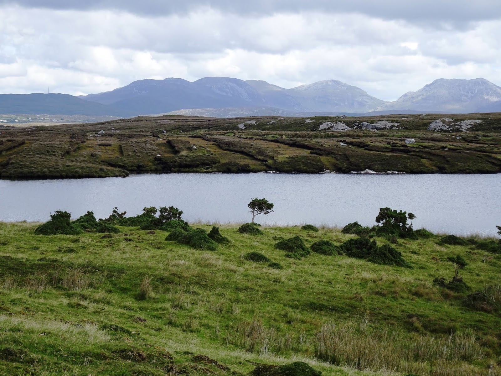
Initially we travelled north west up the side of Lough Corrib on the N59, through attractive small holdings, and then on reaching Oughterard, the terrain became more dramatic, the mountains rising up from the near countryside and the hundreds, even thousands, of little lakes to the right and then to the left. Ougtherrad itself, a small rural service centre is quite attracive, the River Owenriff passing through the town and alongside pretty short walks.
 We
continued on along the N69 until just beyond the barely-there settlement of
Recess, where we turned south west toward Riverstone, a delightful fishing
village tucked up in a sheltered corner of Bertaghboy Bay. The village was
founded in 1824 by the civil engineer, Alexander Nimmo who was born in Scotland’s Kirkcaldy in 1783. While working in this Western
District, he built houses, roads and harbours throughout the West of Ireland.
We
continued on along the N69 until just beyond the barely-there settlement of
Recess, where we turned south west toward Riverstone, a delightful fishing
village tucked up in a sheltered corner of Bertaghboy Bay. The village was
founded in 1824 by the civil engineer, Alexander Nimmo who was born in Scotland’s Kirkcaldy in 1783. While working in this Western
District, he built houses, roads and harbours throughout the West of Ireland.
In
1835, a Franciscan monastry was established in Roundstone and by the
1840s, seventy five houses had been
built. The village supported an active fishing industry as it still does today,
along with the tourists, artists and botanists who pause to enjoy this charming
location.
 After
walking about the village and a welcome cup of coffee, we drove a little
further west then drove a short distance to the delighful sandy beaches of
Gurteen Bay and Dog’s Bay. How attractive this seaside spot was, almost enough
to suggest a swim, although those who emerged from the beautiful clear water
told us it was terribly cold. The moment of temptation passed, but then in
reality my swimmimg togs were back in the caravan, not having been pulled out
since we arrived in the Northern Hemisphere.
After
walking about the village and a welcome cup of coffee, we drove a little
further west then drove a short distance to the delighful sandy beaches of
Gurteen Bay and Dog’s Bay. How attractive this seaside spot was, almost enough
to suggest a swim, although those who emerged from the beautiful clear water
told us it was terribly cold. The moment of temptation passed, but then in
reality my swimmimg togs were back in the caravan, not having been pulled out
since we arrived in the Northern Hemisphere. 
 We
continued on around the R341, from which we had wonderful views, on through
Ballyconneely, to Ballinaboy, where we pulled into Derrigimlagh, labelled a
place of wonder, innovation and daring. It is here on the blanket bog beyond
the car park that in 1907, the great Irish-Italian innovator, Guglielmo
Marconi, combined technology and business acumen to achieve the first
successful commercial wireless transmission of Morse code across the Atlantic
from here. His radio station, which employed up to forty permanent staff at its
peak, dominated the local landscape from 1905 until its partial destruction and
eventual closure during the Irish Civil War.
We
continued on around the R341, from which we had wonderful views, on through
Ballyconneely, to Ballinaboy, where we pulled into Derrigimlagh, labelled a
place of wonder, innovation and daring. It is here on the blanket bog beyond
the car park that in 1907, the great Irish-Italian innovator, Guglielmo
Marconi, combined technology and business acumen to achieve the first
successful commercial wireless transmission of Morse code across the Atlantic
from here. His radio station, which employed up to forty permanent staff at its
peak, dominated the local landscape from 1905 until its partial destruction and
eventual closure during the Irish Civil War.
It
is quite amazing to consider the massive amounts of electricity generated here,
while the area all about had to wait until the early 1950s before they could
enjoy the benefits of electricity themselves.
 This
place was also famous for another life-changing event. In 1919, dare-devil
airmen, John Alcock and Arthur Whitten-Brown, risked life and limb to make the
first non-stop transatlantic flight from Newfoundland to Ireland, a distance of
3,053 kilometres lasting sixteen hours and twenty eight minutes. They crash
landed at Derrigimlagh, mistaking it for a safe landing paddock in the heavy
mist, making it the first European site to connect directly with North America
by aeroplane. Although they did have enough fuel to take them on to London, the
aeroplane’s structure was too wrecked for making that final leg of the journey.
This
place was also famous for another life-changing event. In 1919, dare-devil
airmen, John Alcock and Arthur Whitten-Brown, risked life and limb to make the
first non-stop transatlantic flight from Newfoundland to Ireland, a distance of
3,053 kilometres lasting sixteen hours and twenty eight minutes. They crash
landed at Derrigimlagh, mistaking it for a safe landing paddock in the heavy
mist, making it the first European site to connect directly with North America
by aeroplane. Although they did have enough fuel to take them on to London, the
aeroplane’s structure was too wrecked for making that final leg of the journey. We
parked and headed off along the five kilometre looped walk, seven stop points
telling the stories of the Marconi site, of the accidental landing of those
early avaitors and all about the peat that is still cut out of the bog here.
We
parked and headed off along the five kilometre looped walk, seven stop points
telling the stories of the Marconi site, of the accidental landing of those
early avaitors and all about the peat that is still cut out of the bog here.
Bogs
like this here can be three to four metres deep, but only the top ten to fifty
centimentres are alive. Blanket bogs need
around 1200 ml of rainfall very year to develop and so it is no surprise that
Connemara is home to Europe’s richest bogland.
 It
was no accident that Marconi built his station here at Derrigimlag, not just
because of its wide open, westerly location, but also because the site provided
him with a ready source of fuel in the form of turf. The bog supplied the
station with many hundreds of tons of turf annually; the station in turn provided employment to
local turf-cutters.
It
was no accident that Marconi built his station here at Derrigimlag, not just
because of its wide open, westerly location, but also because the site provided
him with a ready source of fuel in the form of turf. The bog supplied the
station with many hundreds of tons of turf annually; the station in turn provided employment to
local turf-cutters.
 Even
today, many local people have “turbary” rights to cut turf from managed areas
of the bog for their own use. The process of cutting turf by hand has not
changed and remains hard back-breaking work, however the transport of the turf
from bog to place of consumption has. Today we saw areas of the bog that had
been recontoured by past cutting and piles of turf (or peat) wind drying in
“reeks” or ridged piles, ready for future transporting. I picked up a block of
this, expecting it to be heavy like a similar sized soil and vegetation, such
as that my husband and I dug out last year when we were forming new drains at
one of our rentals. This, the Irish peat block, was quite light, and felt as I
imagined a similar sized block of coke. We were interested to learn that peat
is still used as a source of fuel at three Irish power stations: Edenderry,
Lough Ree and West Offaly.
Even
today, many local people have “turbary” rights to cut turf from managed areas
of the bog for their own use. The process of cutting turf by hand has not
changed and remains hard back-breaking work, however the transport of the turf
from bog to place of consumption has. Today we saw areas of the bog that had
been recontoured by past cutting and piles of turf (or peat) wind drying in
“reeks” or ridged piles, ready for future transporting. I picked up a block of
this, expecting it to be heavy like a similar sized soil and vegetation, such
as that my husband and I dug out last year when we were forming new drains at
one of our rentals. This, the Irish peat block, was quite light, and felt as I
imagined a similar sized block of coke. We were interested to learn that peat
is still used as a source of fuel at three Irish power stations: Edenderry,
Lough Ree and West Offaly.
The
walking trail about the sight is variously of tarmac, gravel and boardwalk, and
apart from fellow interested tourists, there are docile sheep and horses about
for distraction of younger members who might find all the technical information
on offer all a bit much.


After
a late lunch, the walk having taken longer than expected, we pressed on again
northward, soon arriving at the small town of Clifden, the recognised capital
of Connemara, this also founded in relatively recent times. Local landlord John
D’Arcy built the town on his private estate in 1812. By 1826, Clifden had one
hundred houses, most of two storeys, along with thirty shops, a brewery, a
distillery and a mill. The area suffered greatly in the Great Famine, but
Clifden recovered somewhat with the arrival of the railway in 1895.
Fourteen
houses were burned down during the War of Independence and others also suffered
destruction during the Civil War that immediately followed, so a great deal of building went on
in the mid-1920s.


Back
on the road yet again, the afternoon now half gone, we continued on along the
N59, and called into the Connemara National Park Visitor Centre, full of every
other traveller who had moved on from Clifden. The car park was overflowing and
the access road was jammed pack with cars parked on both sides at every angle to
allow some sort of temporary stay.
Much
of the present Park, established in 1980, once formed part of the Kylemore
Abbey Estate further on up the road and the Letterfrack Industrial School, this
latter now used as the Visitor Centre which includes a brilliant little museum,
and of course the café and toilet facilities.
 We
spent some time mooching about the museum area, learning that immense forests
of oak and pine covered the greater part of Connemara 7,000 years ago, but in a
further 5,000 years the forests were being cleared away for the needs of an
increasing population, who often set fire to the land for clearing purposes.
This served to inhibit shrub and tree regeneration, unlike Australia where the
trees rely of fire for rebirth, and a large amount of charcoal was produced
which impeded drainage, the soils becoming waterlogged. It is curious to
consider that the burning of land by those early people resulted in the
creation of peat which in later times, or more recently is “quarried” for fuel
.
We
spent some time mooching about the museum area, learning that immense forests
of oak and pine covered the greater part of Connemara 7,000 years ago, but in a
further 5,000 years the forests were being cleared away for the needs of an
increasing population, who often set fire to the land for clearing purposes.
This served to inhibit shrub and tree regeneration, unlike Australia where the
trees rely of fire for rebirth, and a large amount of charcoal was produced
which impeded drainage, the soils becoming waterlogged. It is curious to
consider that the burning of land by those early people resulted in the
creation of peat which in later times, or more recently is “quarried” for fuel
. We
embarked upon a small Nature Trail below the Visitor Centre then returned to
the car, freeing a space up for others pouring into the Park and set off now
heading on a roundabout way for home, concerned about the lateness of the hour.
We
embarked upon a small Nature Trail below the Visitor Centre then returned to
the car, freeing a space up for others pouring into the Park and set off now
heading on a roundabout way for home, concerned about the lateness of the hour.
Instead
of our original planned route, we turned south down the R344 between the two
mountain ranges, emerging onto the lower loop of the N59 again, then turned at
Maam Cross south on the R336 toward the southern coast line and along the
northern shore of Galway Bay until we reached the gates of our camp.
The
day had been absolutely superb, with landscapes and experiences to equal
anything else we had done here in Ireland. This randomly chosen itinerary had
turned into a first class template for touring, if I may say myself.
No comments:
Post a Comment