13 July 2018: As the sun falls lower in
the sky, and now only the very top of the rounded mountain visible from my
window is kissed by the sunshine, we are mentally prepared for our departure
tomorrow. As it happens we have had two
excellent days of touring using this as a base, and could easily have filled
another. However the facilities have not improved and the price was not dropped
when we paid our hostess this afternoon, so we would be slow in recommending
this CS to others. Unless they were intent on climbing Cader Idris on waking in
the morning and were free enough to spend hours conversing with our fascinating
hostess. This incredibly fit woman is a formidable conversationalist for any
who may debate her ideas and ideals, and at this age she is entitled to a few.
So all in all, we will have mixed feelings as we pull out tomorrow morning.
Today we were out onto the road soon after 9 am despite having
slept late. Our route took us south toward Machynlleth, that travelled on our
way here, although the road in reverse was much more attractive; perhaps this
had something to do with the fact we had been both towing and searching for our
destination on Wednesday.

We stopped for a photo opportunity from the sea wall, below which
the stony beach stretches out for some distance, as does the High Street, both
subjected to the weather fronts that arrive in from the Atlantic Ocean all too
often.
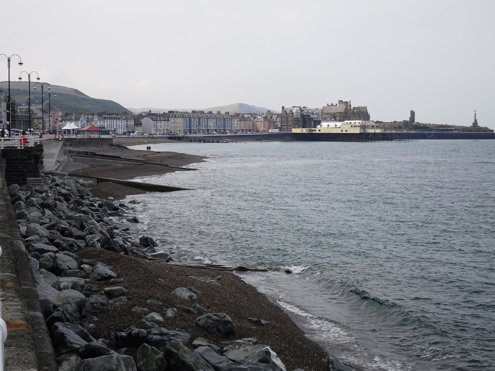 We continued on down this coastal route, a yellow route on our
map, winding its way across sheep farms that sit high above the cliffs between
Borth and Aberystwyth. As we descended to Aberystwyh, we agreed that the town
offered promise, and was certainly worthy of several hours of exploration, and
to that end we found a spot free of charge for four hours at the end of the
promenade; this fact alone made us feel very warm and fuzzy toward this seaside
township sitting midway along the Cambrian coastline.
We continued on down this coastal route, a yellow route on our
map, winding its way across sheep farms that sit high above the cliffs between
Borth and Aberystwyth. As we descended to Aberystwyh, we agreed that the town
offered promise, and was certainly worthy of several hours of exploration, and
to that end we found a spot free of charge for four hours at the end of the
promenade; this fact alone made us feel very warm and fuzzy toward this seaside
township sitting midway along the Cambrian coastline. We learned that Aberystwyth was considered to be the “Brighton of
Wales” as early as 1797, and to its credit it does have a pier, which we
checked out ever so briefly as we passed by. This incredibly ugly structure
does house all the noisy multi-coloured hideous games and machines that other British
seaside places have, although to its credit, it is all inside the building, so
one has only to bear the exterior view.
We learned that Aberystwyth was considered to be the “Brighton of
Wales” as early as 1797, and to its credit it does have a pier, which we
checked out ever so briefly as we passed by. This incredibly ugly structure
does house all the noisy multi-coloured hideous games and machines that other British
seaside places have, although to its credit, it is all inside the building, so
one has only to bear the exterior view. The promenade pier was built in 1865 and the pavilion added the
following year. In the following year the Cliff Railway was built in Constitution
Hill with new theatres, cinemas an concert halls appearing during the early 20th
century. A bathhouse graced the seafront from as early as 1800, soon after
pleasure gardens had been laid out around the castle.
The promenade pier was built in 1865 and the pavilion added the
following year. In the following year the Cliff Railway was built in Constitution
Hill with new theatres, cinemas an concert halls appearing during the early 20th
century. A bathhouse graced the seafront from as early as 1800, soon after
pleasure gardens had been laid out around the castle.
Nearby is the Old College, a John Nash designed turreted villa
dating from 1790, which was later significantly extended in the 1860s, as a
hotel to accommodate the anticipated tourist numbers when the railway arrived.
The venture failed and in 1872, the complex was sold to the fledgling
university, whose property it remains.

Aberystwyth is also known as “a place of learning”, home to the
National Library and the Aberystwyth University, one of the United Kingdom’s
most prestigious educational institutions.
Until the second half of the 19th century, education in
Aberystwyth was provided by religious classes and private schools, but as most
people here were nonconformists, the desire to set up a non-denominational school
grew in the town. In 1871, Aberystwyth became the first town in Wales to elect
a School Board, which led to the building of the town’s first nondenominational
school with places for six hundred children.
Along with the establishment of the University and the
nondenominational school, Aberystwyth met another educational milestone when
the first Welsh language primary school was opened here in 1939.


We
decided that we had seen there was all there was for us in Aberystwyth,
returned to the car and set off up the Rheidol valley. We drove up along the
southern edge, high above the river and high above the railway line that runs
from Aberystwyth along its narrow gauge as far as Devil’s Bridge, rising 600
feet in the process and has done so since 1902. Then it was for more
utilitarian purposes, to cart out lead from the mines up in the valley,
although the entrepreneurs always had in mind to swap lead for paying tourists.
We stopped along the route, beside drought dry farmland and zoned
out sheep, to eat our lunch. The brown
of the pastureland has become more yellow with the passing of the days, despite
the showers of rain that passed over yesterday. Distant views were lost in the heat
haze but were still a treat over our sandwiches and pains au raisin picked up
at Morrisons.
 Devil’s Bridge had been noted on the map three years ago when we
came through this part of the country in the motorhome, so I was delighted that
we had the time and the inclination today to check it out. Folk legend gives
the bridge its name, and the bridge gives the village its name, but the eye
catching attraction is the three stacked bridges across the River Mynach, one
on top of the other. The first is a stone foot bridge dating from medieval times,
the second another stone construction to carry wagon traffic built in the early
1800s, and the current one built above in the early 20th century.
Devil’s Bridge had been noted on the map three years ago when we
came through this part of the country in the motorhome, so I was delighted that
we had the time and the inclination today to check it out. Folk legend gives
the bridge its name, and the bridge gives the village its name, but the eye
catching attraction is the three stacked bridges across the River Mynach, one
on top of the other. The first is a stone foot bridge dating from medieval times,
the second another stone construction to carry wagon traffic built in the early
1800s, and the current one built above in the early 20th century.
Directly below the fast flowing river, or at least in flood time,
the water has carved a series of rock bowls, and these and a decent view of the
bridges can be accessed by a walk through a coin operated turnstile, at £1 per
person. We did consider squeezing into the one space, however the iron quarters
are not made for fatties, and certainly not for a couple, no matter how cosy
they wish to get.

So instead we drove on, now north east onto the A44, across
wonderful landscapes, rural and mountainous, then turned north onto the B4518
at Llanidloes, heading across a “mountain road” but one with two lanes marked
and an excellent surface. About three miles up this road, we turned into the
Llyn Clywedog, the reservoir built on the River Clywedog back in the mid-1960s
to control the flow of water into the River Severn, preventing flooding in
winter and supplying a regular supply in the summer.

 Further on, now at some elevation, we turned left up a minor
road marked white on our map, and came over even more mountainous land,
eventually dropping directly down into Machynlleth. We pulled into a park to briefly
consider a return to the excellent little art gallery there, MOMA Cymru, the
Museum of Modern Art, Wales, but checking our guide book saw that it would
close in twenty minutes and by the time we walked back into the town we would
be left with little time to enjoy our visit. We pressed on, soon back at our
camp.
Further on, now at some elevation, we turned left up a minor
road marked white on our map, and came over even more mountainous land,
eventually dropping directly down into Machynlleth. We pulled into a park to briefly
consider a return to the excellent little art gallery there, MOMA Cymru, the
Museum of Modern Art, Wales, but checking our guide book saw that it would
close in twenty minutes and by the time we walked back into the town we would
be left with little time to enjoy our visit. We pressed on, soon back at our
camp.
This afternoon several walkers have arrived and set up camp in various
corners of the coarsely scythed field; the primitive facilities will be pushed
to the limit. This would not normally bother us, because we are at an informal
camp, but paying £20 per night is above the norm. And this is our discounted
Club rate; these casual guests will be paying £25 each at the very least.
On the plus side, we have not been subjected to the impossibly
noisy aircraft this afternoon, although they have been known to come by soon
after dark. The only noise is the farm machinery passing by as it moves from
one hay field to the next, and nightfall will soon put an end to that.
No comments:
Post a Comment